
Wet weather is back with intensifying rain at times for the next day to day and a half.
Showers will form along the south coast and Cape Friday morning as heat and high humidity both remain. The showers will form along a stationary front that’s parked along the I-95 corridor and bubble up on and off through Saturday morning and the early afternoon.
STAY IN THE KNOW
Watch NBC10 Boston news for free, 24/7, wherever you are. |
|
Get Boston local news, weather forecasts, lifestyle and entertainment stories to your inbox. Sign up for NBC Boston’s newsletters. |

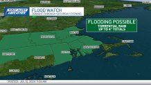
As you’ve noticed as you step outside, the humidity is still high, it feels tropical and sticky out. The atmosphere is very moisture-laden, and does come from the tropics. Intense downpours and flooding will be possible at times as rainfall rates near 2 inches per hour.
329 medal events. 32 sports. Endless drama. Catch all the action at the Paris Olympics. Sign up for our free Olympics Headlines newsletter.

We’re under a flood watch across much of Massachusetts tonight and through Saturday evening.
While widespread severe weather isn’t expected, there will be thunder and lightning at times.
Weather Stories


As the rain departs, we’re still left with humid and hot conditions Sunday and through much of next week. Another heatwave is expected Sunday to Wednesday, with feels-like temperatures near 100°.
There may be a break in the heat though, as signs point to a “cool down” at the tail end of the forecast period, where highs drop into the low 80s.
