We have you in a First Alert for impactful weather across the region the next couple of days as an early season nor’easter makes its way towards us. Rain, wind and waves are on the way, so let’s break down the storm piece by piece.
Rain
WATCH ANYTIME FOR FREE
Stream NBC10 Boston news for free, 24/7, wherever you are. |
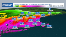
The rain will fill back in Monday night and fall steadily and at times heavily throughout the day Tuesday, tapering slowly in intensity and coverage from west to east on Wednesday. A widespread 2 to 4 inches of rain is expected, with locally higher totals possible, especially across Connecticut.
Amounts will decrease as you head north. A flood watch is up for much of southern New England, with a flash flood watch in southern Connecticut. Fallen leaves on the roads will make it extra slick, so please allow plenty of time to get where you need to be these next couple of days; it’s going to be a slow go.
Get updates on what's happening in Boston to your inbox. Sign up for our News Headlines newsletter.

Wind
Weather Stories
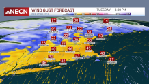
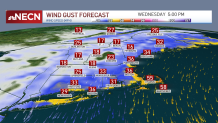
Gusts will start to cause scattered damage and outages by Tuesday evening and will be strongest in eastern Massachusetts, particularly from Cape Ann to Cape Cod and the coast of the South Shore (50 to 60 mph). Even inland, gusts of 40 to 50 mph will result in pockets of outages from Tuesday evening into Wednesday morning.
The wind will shift just slightly to blow out of the north-northeast and then north later Wednesday before gradually easing inland and taking all day to do so elsewhere. In fact, Cape Cod may still be gusting to 55 mph Wednesday night.


Waves
Our seas will build 5 to 15 feet through the day Tuesday with some 20 foot waves just off the coast of the outer Cape by Wednesday. Thankfully, tides aren’t astronomically high. However, with this much wave action, battering surf, beach erosion and minor coastal flooding will result.

What's next?
We get a brief break in the action Thursday before another potential nor’easter heads our way late Friday into the weekend.
Right now, we’re optimistic that after raining much of Saturday into early Sunday, some gradual improvement will move in just in time for trick-or-treating Sunday evening. Stay tuned!
Preparations
Ghosts, goblins and a potentially powerful nor'easter. It all adds up to a pre-Halloween mess that has Massachusetts communities making preparations ahead of the storm's arrival.
Plumber Anthony Mound advises people to test their sump pumps now. He says every time it rains, the calls flood in.
Boats were being pulled from the water Monday in Quincy, but the deputy harbormaster is hoping the storm won't be as bad as its predicted.
Quincy Mayor Thomas Koch and the city's Department of Public Works are also watching the storm closely. With nearly 30 miles of coastline, the city's tide gates have been inspected and are ready to go.
"We take this all seriously, we can't fool around with this because we would lose a neighborhood if we do," Koch said.


