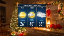
Temperatures fell to the 20s overnight, and the wind has diminished.
There are some slick spots early Wednesday morning due to some refreezing. We are waking up to chilly, but dry conditions.
There will be no white Christmas this year in Boston since all the snow melted away earlier this week.
Our weather pattern continues to be calm and quiet for your Christmas Day celebrations. Highs will be around 40 degrees with increasing clouds in the late afternoon, but great travel weather across the northeast.
Thursday afternoon will be similar to Wednesday, with highs again around 40 and a little less cloud cover. Our next chance for precipitation will move in Friday morning with a brief wintry mix in higher terrain. Then, we quickly switch to scattered rain showers as a warm front lifts to the north.

We dry out in time to kick off the weekend. Saturday will be warmer with highs in the mid-40s and some sunshine.
Local
In-depth news coverage of the Greater Boston Area.
Sunday afternoon, another system will head our way, but it looks more rainy than snowy as our temperatures will still be in the 40s. Temps may actually rise to the low 50s behind a warm front late Sunday night and early Monday morning, before falling to the mid-40s by Monday afternoon. Scattered rain continues into Monday, with a wintry mix in the mountains.
Tuesday morning, colder air arrives behind a cold front. We switch to brief and light snowfall for Tuesday morning, clearing in time for the New Year’s Eve festivities. New Year’s Day will be dry and in the low 40s. No major cooldowns in the 10-day, but we are watching for a possible system for next Thursday into Friday.


