
Today: Fair, brisk, breezy, slight chance PM sprinkle. Highs in the 50s. Gusts to 30 mph from the southwest. Overnight Wednesday Night: Slight chance Cape shower, otherwise partly cloudy. Lows in the 30s with frost inland. Thursday: Breezy & bright. Highs in the 50s.
Good chilly Wednesday! Drier and cooler conditions have settled in and plan to stay through Friday morning. We’ve woken up to temperatures in the 30s with highs that will struggle to reach the upper 50s Wednesday. Most of us will feel in the lower 50s thanks to a decent southwesterly breeze.
WATCH ANYTIME FOR FREE
Stream NBC10 Boston news for free, 24/7, wherever you are. |
The warming trend will start on Friday, with highs climbing into the lower 60s and keeping those 60s through the weekend. What’s best of all is that we’ll get to enjoy rays for days. Clear skies take over Wednesday, Thursday, Friday and Saturday! While overnight temperatures will drop to the 30s and allow for some frost, the sun makes up for it through the afternoons as we warm our way up to more seasonable values.
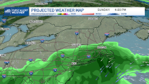
Where’s the rain? It makes its comeback with a statement. We’ll see the chance for showers returning for what’s left in the 10-day forecast. From late Sunday into the following Thursday, the probability for rain will range from a 30-60% across New England. While not all of our area will get rain at the same time, several systems will brush into New England. A coastal storm will swirl in from the south and bring rain on Sunday into Monday. Another frontal boundary will push in from Tuesday into Wednesday. And with a meandering low, we’ll see unsettled weather remaining through Thursday.
Get updates on what's happening in Boston to your inbox. Sign up for our News Headlines newsletter.
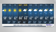
Highs will continue to range from the low to upper 60s through all of next week too. Enjoy the sun, the crisp nights and the amazing near peak foliage across southern New England these following days.