Snow did materialize for some, but not for all last night. Plenty of snow envy on the social media feeds. However, those that were stiffed by Ol’ Man Winter may find solace in knowing that everyone will see the snow vanish in the coming day(s).
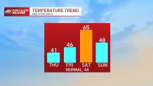
Milder air is once again on the move, and some 60 degree days have again appeared on the extended range forecasts. Today’s a chilly one, in contrast.
WATCH ANYTIME FOR FREE
>Stream NBC10 Boston news for free, 24/7, wherever you are. |
With cold air flowing down in the wake of last night’s storm, temperatures will struggle to make it out of the 30s in many spots. Hard freeze is on tap again tonight before the clouds race in with the next weather system.

Get updates on what's happening in Boston to your inbox. Sign up for our >News Headlines newsletter.
Tomorrow sees the warm front lifting by. Not much other than some clouds with this. There is a possibility of some wet snow flakes or VERY brief mix in the early part of the day as this front sneaks by, but the sun should be able to make a cameo by afternoon.
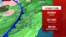
Then the floodgates of warmth flow in ahead of our next feisty storm system. This one will be loaded with rain and a charging southwest wind.
We’re a little concerned about the possibility of some isolated power outages as winds peak at 40-55 mph later in the day Saturday. In addition, the atmosphere will become fairly unstable, and thunder could be a distinct possibility later in the afternoon/evening. It’s becoming all too familiar these days.

Longer range, the pattern is solidly mild. We’re wrestling with a nearby front into early/mid next week, but the temperatures should still average above normal.
Weather Stories
Later in the week, a bombastically warm surge of air should catapult us well into the 60s by Thursday or Friday. This is the type of setup that yields 70 degree temperatures in December (yes, it’s happened a few times before), so prepare to be astounded in forthcoming forecasts.


