Heat and humidity stage a comeback today. With highs soaring back to the mid-80s in spots, it will feel every bit of summer - minus the vacation on the Cape.
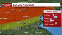
Instead, we’ll be treated to a line of intense thunderstorms firing across New York and Vermont around midday. These storms will crawl to the east through the day, likely reaching outermost Rt. 2 near Gardner and Orange – and north to Keene - in the late afternoon/evening.
WATCH ANYTIME FOR FREE
>Stream NBC10 Boston news for free, 24/7, wherever you are. |
There’s plenty of fuel out there to keep them alive and kicking, but as they move farther from the front that touched them off in New York, they will weaken.

Get updates on what's happening in Boston to your inbox. Sign up for our >News Headlines newsletter.
Nevertheless, it’s wise to keep an eye for storms from 4 p.m. to 7 p.m. approaching from the west. Greater Boston may never see these nasty storms, but instead could see them as lighter rain showers late into the night. That’s how slow this line will be moving.
As a result, there may be pockets of flash flooding as the skies open up under the clouds. Our other worries revolve around strong wind, possible hail and frequent lightning. Wind speeds could reach between 30 and 60 mph with a low risk of possible tornado formation.
Everything settles down tonight as the storms fizzle to occasional showers. Humidity will hang on, but the changing wind direction means the 80s are out of the picture for a while. In their place, we’ll struggle to make 70s along the coast under a cloudy, sprinkly sky.

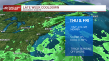
In other news, a tropical depression is likely to form either tomorrow or Friday as it parallels the Eastern Seaboard. It’s not a threat to land, but will keep our frontal boundary today from clearing the coast until Friday night (or even early Saturday morning).
Weather Stories
We’ll slip back into the cooler air, but we won’t do much to break up the clouds as they swirl in from the ocean. This will also keep the temps on the cool side through the end of the week. The sun slowly returns to the picture on Saturday.
We’ll keep you posted through the afternoon and evening on the severe weather potential.


