We’re far from improving – never mind banishing - this drought situation. I’ve heard many people say, “We got rain (x) days ago, we aren’t that bad off.”
That’s been the case since early spring. Frequent little jabs of light rain or drizzle give the impression that, “It’s rained, we’re fine.” But we know it’s quantity, not frequency, that’s the problem.
WATCH ANYTIME FOR FREE
Stream NBC10 Boston news for free, 24/7, wherever you are. |

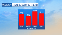
And the heat will be getting more intense in the days ahead. While Tuesday sees a return to 90 degree weather, Wednesday the numbers should slump along the coast thanks to a sea breeze. This breeze will knock coastal communities back to the low/mid 80s. Elsewhere, it’s another day in the 90s. In fact, the run of 90s is likely to extend into the weekend as the heat really gets out of hand by Thursday.
Get updates on what's happening in Boston to your inbox. Sign up for our News Headlines newsletter.

As the mid-levels of the atmosphere warm - to the same levels we saw on July 24– we’re expecting to break records AND reach for 100 degrees in some spots. With the winds coming from the southwest, Boston is also in that fiery grouping. Heat indices will also peak in the sweltering zone with lots of humid air in place. Some spots may feel like 103-105 degrees by afternoon. It’s a good idea to take it slow and easy if you’re planning on spending any time outside.

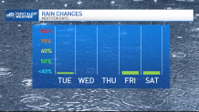
The tail end of the week offers hope for the drought. We have a *chance* of storms – but wait, this may be different. With a stalled front nearby for at least three days, we could get some nice hits with slow-moving storms. That said, it may be too much of a good thing too. Water-logged slow-moving storms could spell flash flooding. We’ll keep watching this situation evolve, but for now, stay safe in the heat!


