
Thursday will be mild, with heavy wind returning Friday and Saturday. Watch the video to see what else to expect.
A taste of spring continues, but it won’t come without some active weather.
A frontal system will bring a period of steady rain late this evening into early Thursday, accompanied by gusty southerly winds and unseasonably mild temperatures. Rainfall amounts will range from 0.5 to 1.5 inches, with brief downpours possible overnight. Winds will pick up, especially along the South Coast and Cape Cod, where gusts could reach 40-50 mph at times.
WATCH ANYTIME FOR FREE
Stream NBC10 Boston news for free, 24/7, wherever you are. |
Minor coastal flooding is possible during high tide due to the strong southerly flow. Temperatures will hold steady in the 50s overnight into Thursday morning. Thursday's lows will be above the normal high of 42 degrees for early March. Rain will taper off for Southern New England early Thursday. Lingering clouds and breezy conditions will remain before a strong cold front moves in late in the day, shifting winds to the northwest and setting the stage for a colder, blustery end to the week.
Get updates on what's happening in Boston to your inbox. Sign up for our News Headlines newsletter.
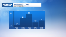
Temperatures crash Friday and land in the upper 30s and low 40s for highs. Cooler air paired with northwest wind gusts near 50 mph at times will make for a frigid feel. This sharp cooldown will be short-lived, as temperatures moderate slightly over the weekend. A clipper system passing through on Saturday could bring a few scattered rain or snow showers, but no significant storm is expected. Looking ahead to next week, temperatures will trend back above normal. Highs will climb into the upper 40s to low 50s by Monday and Tuesday.