
While impacts from Helene aren't expected in Boston, we're keeping an eye on the storm as it tracks toward Florida and the southeastern U.S.
As of Wednesday morning, the storm's future looks promising as it exits the Yucatan Peninsula and nears the southeastern tip of the Gulf of Mexico. The future of the storm will feature rapid intensification and strengthening into a monster storm. Tropical storm force winds extend 175 miles from the center of the storm, which is nearly a 350-mile-wide storm.
WATCH ANYTIME FOR FREE
Stream NBC10 Boston news for free, 24/7, wherever you are. |
As of 11 a.m., the National Weather Service said Helene had reached hurricane strength.

Get updates on what's happening in Boston to your inbox. Sign up for our News Headlines newsletter.
Previously, the storm was about 140 miles wide. This wide side will allow strong winds to push the waters of the Gulf of Mexico up Florida’s west coast. This will generate storm surge that peaks around 10-15’ in the Big Bend region and will cause issues even through the Tampa Bay.

By Thursday afternoon, the storm will be nearly 400 miles wide, as the tropical storm force winds touch Florida’s east coast too, with surge possible, though not as high.
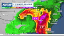
Beyond landfall, the history of this storm will be the water threat from the sky, with inundating rain through the Georgia coastal plains and Blue Ridge parkway through Tennessee. 6-12” of rain is possible through Friday night along Southern Appalachia.
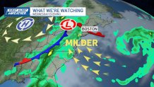
But that’s about where the storm stops. We’ll be protected from the tropical rain, thanks to a larger area of high pressure in the region. On the other hand, showers will be possible in New England on Thursday, for a different, and much smaller scale storm system. Thursday’s rain should start around 1pm and last through the evening. While there will be breaks, a final line of showers advances in Thursday night around 11pm. This will mean drier air comes back on Friday, with sun in pockets. High temperatures are near 70° Friday, and the upper 60s throughout the weekend.

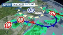
It’s a pleasant weekend here at home to enjoy fall in New England. Pumpkin patches and apple orchards are the place to be – as we near peak fall foliage in a few weeks!