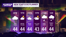
The dry weather continues through much of this New Year’s Eve…until midnight. High temps top off in the low 50s again with a mix of clouds and sun.

WATCH ANYTIME FOR FREE
>Stream NBC10 Boston news for free, 24/7, wherever you are. |
When does the rain start on New Year's Eve?
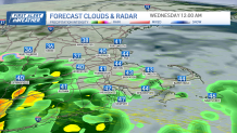
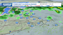
As you head to First Night festivities in Boston, our next low pressure system heads in from the Midwest. The showers begin right around midnight and will last through daybreak on New Year’s Day. Downpours and a couple of thunderstorms will be around as folks head home from any late-night parties. The rain tapers and moves out by tomorrow afternoon.
Get updates on what's happening in Boston to your inbox. Sign up for our >News Headlines newsletter.

What does the weather look like for New Year's Day?
Temps will be in the 40s for most on Wednesday as colder air begins to filter in from the northwest. Northern New England will see a coating to a couple inches of snow in the valley, and the mountains could get 5-8” + of snowfall through the day.


Our wind could be as high as 40 mph by Thursday with temps in the 30s. High terrain will see 50-55 mph winds and this means some outages or damage will be possible in those areas, especially combined with the weighted snowfall.

With the wind and the cold airmass aloft, we will see lake-effect snow to our northwest, and ocean effect snow off our coast, but much of New England will remain dry, sunny and chilly Friday. This set up continues through the weekend with colder temps in the low 30s will be in store for both days.
Weather Stories
What's the weather outlook for the first week of 2025?
Next week there is a nearby ocean storm around Monday that would bring a mix of rain and snow to southern New England. Today the forecast models shifted this storm so far south, it’s a miss for us. But stay tuned for updates on this, as the track could still change. Happy 2025!


