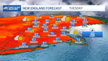
It's a beautiful start to the new work week with temperatures close to average along with low humidity, once again. High pressure will be our dominant feature providing an onshore flow keeping temperatures a bit cooler than what we saw Sunday along the immediate coast.
Most of the region will be on the dry side but can't rule out a few isolated showers popping up over the interior Monday afternoon, where an upslope in wind direction may help trigger them off. Highs upper 70s to 80 coast, low 80s inland, upper 70s higher elevations.
WATCH ANYTIME FOR FREE
>Stream NBC10 Boston news for free, 24/7, wherever you are. |

Winds will be on the increase Monday night out of the southeast as low pressure develops south of New England and high pressure loosens its grip. We will remain on the dry side with clouds on the increase, though a stray shower or sprinkle is not out of the question for the Cape and Islands.
Get updates on what's happening in Boston to your inbox. Sign up for our >News Headlines newsletter.
Lows in the 60s south, 50s north. The big question that still remains is the track of a developing coastal storm south of New England during the mid-week.

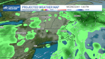
It would be great if its precipitation shield could make it into the region since much of the area is dealing with a drought, but forecasting models have had a bit of trouble the past few days determining the system's exact track. At the very least, Tuesday night through Thursday morning looks a bit unsettled with showers around, especially along the coast.
If the storm takes a more inside track, portions of the region could end up with an appreciable rainfall along with some gusty winds thrown in as well. We'll be monitoring it closely!

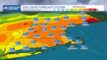
One other point to make is that our exclusive in-house model is keeping a greater than 70% chance for some rain Wednesday for a majority of the region, which would be a welcomed sight if it pans out and it does have a very good track record! Like I've been saying much of the summer, keep doing those rain dances, it's bound to come!

