
Today: Rainy and cool. Highs around 50, 60s South Coast. Overnight Tonight: Showers exit for gradual clearing. Lows in the 30s for many, 40s south. Tuesday: Fall chill with a fair sky. Highs near 50. Wednesday: Variable clouds with scattered showers of raindrops mixed with snowflakes at times. Highs in the 40s.
Warmth from the weekend was snuffed out long ago, but the rain is another story. Showers continue to chase us Monday morning as a small storm system forms to our south. This will create some periods of heavy rain for a time through noon, with showers tapering to sprinkles/pauses throughout the afternoon.
We'll shut down the showers after dark as skies clear later into the evening.
WATCH ANYTIME FOR FREE
Stream NBC10 Boston news for free, 24/7, wherever you are. |

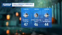
A chilly (some would say cold) Halloween forecast is in store Tuesday. It’s worth noting that the forecasted high of 50 would be our coldest Halloween temperature in three years. The pre-Halloween snowstorm in 2020 chilled that Halloween high to 42 degrees.
Get updates on what's happening in Boston to your inbox. Sign up for our News Headlines newsletter.
Since then, we've been pretty mild, with 68 last year and 67 in 2021. Trick-or-treating will be in the 40s by Tuesday evening with a bold (but not full) moon to light the pathways and appease the werewolves.
We'll be watching a small storm offshore on Wednesday that will give us a glancing shot at some showers. The air is chilly enough that some form of frozen precipitation (perhaps graupel) will fall in spots, especially in the Worcester Hills. While no reason for alarm, it shows just how cold the air is upstairs.


We'll have a solid chance at a widespread freeze on Thursday morning in the suburbs, with a chance even the immediate suburbs of Boston get a chance at a frost. Then, a slow warmup will take us into the weekend. Nothing summery is in store, but we could see 60s return for a cameo.
Enjoy the week!