A remarkably mild pattern not only graces trick-or-treaters with comfortable weather for strolling, but is expected to stick around all the way through the upcoming weekend!
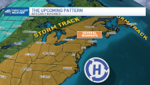
On the big picture, a large-scale restructuring of the jet stream winds aloft is the driver in this mild pattern. The jet stream is the fast river of air at high altitudes that steers storm systems across the country and separates cool air to the north from warmth to the south.
WATCH ANYTIME FOR FREE
>Stream NBC10 Boston news for free, 24/7, wherever you are. |
A large trough, or dip, in the jet stream will develop over the western United States this week, and an equal but opposite response here in the east will mean a ridge – or northward bump – in the jet stream.

Get updates on what's happening in Boston to your inbox. Sign up for our >News Headlines newsletter.
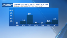
By transitioning to the southern side of the jet stream, the eastern United States will see warmth expanding, with New England temperatures warmer-than-normal all the way into next week! As the jet stream makes that transition, it will throw one disturbance our way with showers overnight Monday night through Tuesday, but this should be after trick-or-treat time, with the bulk of Monday and Monday evening featuring temperatures peaking in the 60s, hovering in the 50s in the evening and night, and nary more than a passing sprinkle from time to time.
As showers increase after midnight Monday night, temperatures will remain mild, courtesy of a southwest breeze, and fog will be limited mostly to hilly terrain.
Tuesday brings off and on showers, particularly to the southern half of New England, with high temperatures in the 60s ahead of a cold front that’s expected to cross New England Tuesday night. That'll deliver drier air for returning sunshine Wednesday onward, and a shot of cooler air that will especially noticeably Thursday, but still yield an afternoon high temperature around 60 degrees – still a few degrees above normal for this time of the year.

Heading into the weekend, New England will realize the impact of a northward rising jet stream ridge, with already-elevated temperatures for early November rising even more…into the 70s for some by Saturday and Sunday! Saturday’s records are already pretty warm (79° in Boston, for example) but Sunday’s are more vulnerable to being broken (73° in Boston, for instance).
Weather Stories
Our First Alert Team does expect the mild air to linger into early next week before a change in the weather pattern cools us down considerably, closer to where we should be, in the middle 50s, by the middle of next week in our exclusive First Alert 10-day forecast.


