
Highs will be in the 50s Wednesday and Thursday. Watch the video to see what else to expect.
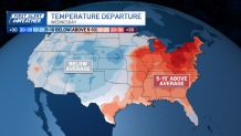
I hope we are all enjoying this warmer stretch — it will stick around with a few bumps in the road, but generally above normal temperatures to kick off spring in two days.
Tuesday afternoon will be cloudy along the coast with pops of sun inland, with highs in the 50s. If you're near the coast, expect it to stay a bit cooler in the upper 40s to low 50s thanks to an onshore breeze that will stick around into Wednesday. Tonight will be clear and cool in the upper 30s.
WATCH ANYTIME FOR FREE
Stream NBC10 Boston news for free, 24/7, wherever you are. |
Wednesday looks fantastic with plenty of sunshine, but temperatures will vary quite a bit—mid-60s out west while the coastline stays in the upper 40s to low 50s due to an on shore breeze.
Get updates on what's happening in Boston to your inbox. Sign up for our News Headlines newsletter.
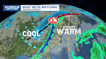
Thursday morning, clouds build, and some light sprinkles are possible. Thursday night, a system moves in, bringing rain through early Friday morning.
As colder air moves in, some of that rain could switch to snow in the higher elevations—mainly in the Berkshires, Green and White Mountains—where accumulations are possible. Elsewhere, expect just a soggy start to Friday before rain tapers off by midday.

The wind will kick up as this system brushes by Friday, with gusts up to 40 mph, possibly stronger in the hills. Friday will be cooler with highs in the 40s, but we warm back up into the 50s over the weekend with dry weather on Saturday. Looking ahead, temperatures stay close to or slightly above normal into next week.