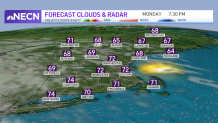
The high-pressure system from Canada that moved in yesterday with this nice refreshing air remains in place for our Monday. That means another nice day with plenty of sunshine and relatively low humidity.
There are some cirrus clouds dimming the sun a bit, especially in southern and western New England, but high temperatures get back to the 70s to near 80°. The wind is fairly light from the north this morning, and becoming locally onshore this afternoon at about 10 to 15 mph, while remaining near calm inland.
WATCH ANYTIME FOR FREE
>Stream NBC10 Boston news for free, 24/7, wherever you are. |
We have another comfortable night coming up with a few clouds blocking out the evening moon, but remaining a mostly fair sky with low temperature again in the 50s and 60s.

Get updates on what's happening in Boston to your inbox. Sign up for our >News Headlines newsletter.
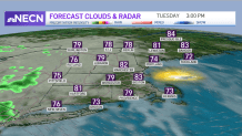
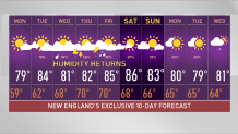
As high-pressure moves offshore tomorrow we’re going to get a bit more humidity with clouds working into the afternoon sky. Temperatures tomorrow recover back to the low and mid 80s with wind becoming southerly at 10 to 15 mph.
Showers with the leading edge of warmer and more humid air are getting close tomorrow evening and a few of us may get a bit of rain tomorrow night, especially in Western in New England. As it becomes more humid our nighttime lows will be more like the 60s to near 70° by the middle of the week.

The big question for the second half of the week is, how much rain do we get?
Weather Stories
We will have at least scattered showers and thunderstorms, but there’s a wild card with the remnant of tropical storm Fred working through the southeastern United States.
Fred may maintain itself as a low pressure system that could cross Southern New England Wednesday night into Thursday. If that’s the case, we may measure rainfall in inches, the most likely area for the heavier rain is central and southern New England.
We’re also monitoring the progress of tropical storm Grace bringing flooding rain to parts of Hispaniola and Cuba today and tomorrow. That storm will be in the Gulf of Mexico by late week and into the weekend.
There’s also another tropical system near Bermuda, potential tropical storm Henri, meandering very close to Bermuda, but likely staying over the ocean.
By late week and into the weekend we probably get a push of less humid air coming in from Canada. The timing may be similar to what just happened with the cooler and drier here returning at some point later Friday or Saturday.
Stay tuned to our First Alert 10-day forecast for the latest updates.


