
Temperatures will creep into the 60s Sunday before dropping back down Monday far enough that some areas may see sleet and snow. Outside New England, we’re watching the potential for more severe weather in the south. Here’s your First Alert forecast.
Follow NBC10 Boston:
https://instagram.com/nbc10boston
https://tiktok.com/@nbc10boston
https://facebook.com/NBC10Boston
https://twitter.com/NBC10Boston
https://bsky.app/profile/nbcboston.com
Rain continues Sunday morning, with showers into midday before tapering off in the afternoon.

Stream NBC10 Boston news for free, 24/7, wherever you are.
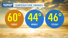
A temperature roller coaster continues as well. Expect temperatures to climb into the upper 50s to 60 Sunday afternoon, with drier northwest winds and a brief break in the wet weather.
Get updates on what's happening in Boston to your inbox with our News Headlines newsletter.
Rain redevelops Sunday night as low pressure moves along the stalled front. Colder air will allow for a wintry mix across the interior, especially north of the Mass Pike and in higher elevations where a slushy coating of snow or sleet is possible by early Monday.

Rain continues Monday morning, with areas of mix or snow lingering in the higher terrain before tapering off by the afternoon.

Cooler highs continue Tuesday, along with breezy conditions and a few spotty showers. Tuesday’s highs will struggle to reach the mid 40s, and it will feel colder with the wind. Wednesday looks dry but still cool, before a warming trend kicks in late week. Highs Thursday and Friday may reach the 50s, but another round of rain looks possible by late Friday into Saturday.