
Spring is taking a break as we track a cool down, with rain & flurries entering the area this morning. Here’s your First Alert forecast.
Follow NBC10 Boston:
https://instagram.com/nbc10boston
https://tiktok.com/@nbc10boston
https://facebook.com/NBC10Boston
https://twitter.com/NBC10Boston
https://bsky.app/profile/nbcboston.com
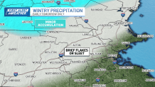
We’re taking a step back today. Some sleet pellets and/or snowflakes (egad!) may fall early in the day as leftover cold from last night lingers into mid-morning.
WATCH ANYTIME FOR FREE
Stream NBC10 Boston news for free, 24/7, wherever you are. |
Will it snow in Massachusetts on Monday?
No accumulation is expected – unless you are north of Fitchburg, Nashua, and Portsmouth, New Hampshire. It’s here that we may see a coating of snow through midday. Thereafter, it’s a cold rain for everyone. Highs only make it to the upper 30s to low 40s – falling short of our normal high of 48 (Boston) in late March.
Get updates on what's happening in Boston to your inbox. Sign up for our News Headlines newsletter.

Tomorrow fares a bit better as sun and clouds mix with a cool northwest breeze. On Wednesday, a small storm system will move off the Islands. We may be close enough for a few showers, but this isn’t a washed-out day like today.

Overall, the week appears fairly quiet but cool. We’ll fall back to the upper 40s Thursday, then nudge 50 on Friday.
Local
In-depth news coverage of the Greater Boston and New England area.


The aurora borealis was a little more active over the weekend. We came in just below the threshold for vibrant nighttime colors, but some spots in New England did get a little show. As solar activity wanes in the coming days, we’re not expecting anything significant to strike Earth. We remain in a solar maximum, so be alert for more activity in the months to come!