


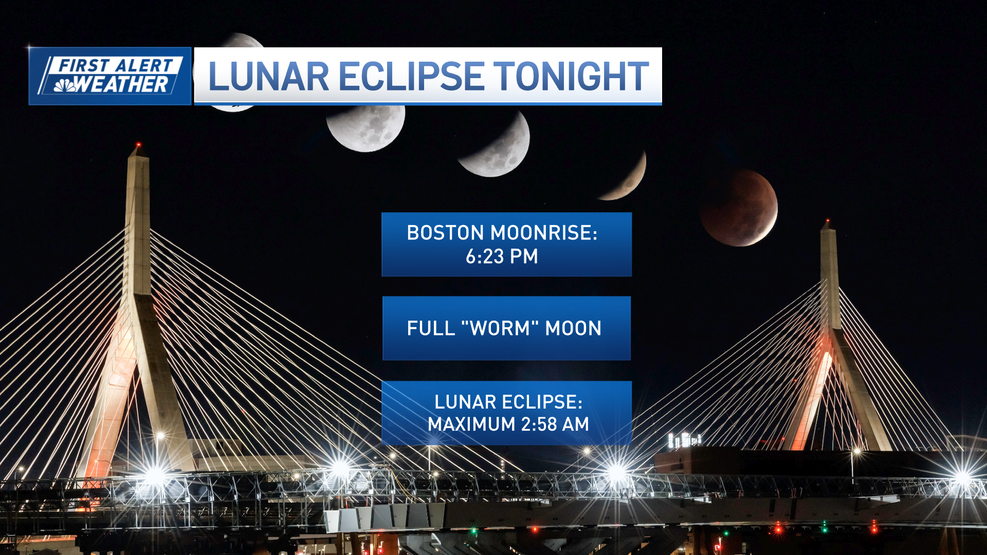
Early Friday morning brings us a total lunar eclipse! The Earth’s shadow will turn the moon blood red for just over an hour. Here’s when to see it and what to know about cloud cover tonight.
Follow NBC10 Boston:
https://instagram.com/nbc10boston
https://tiktok.com/@nbc10boston
https://facebook.com/NBC10Boston
https://twitter.com/NBC10Boston
https://bsky.app/profile/nbcboston.com
Our coolest day of the 10-day forecast is upon us. Temperatures remain in the low 40s at the coast with some 50s inland.
Thanks to the consistent easterly breeze off the low 40 degree ocean water temps, it’s a brisk day at the shore. This also means moisture from the ocean will keep clouds around overnight during our lunar eclipse.
WATCH ANYTIME FOR FREE
Stream NBC10 Boston news for free, 24/7, wherever you are. |

What time does the lunar eclipse start tonight?

Get updates on what's happening in Boston to your inbox. Sign up for our News Headlines newsletter.
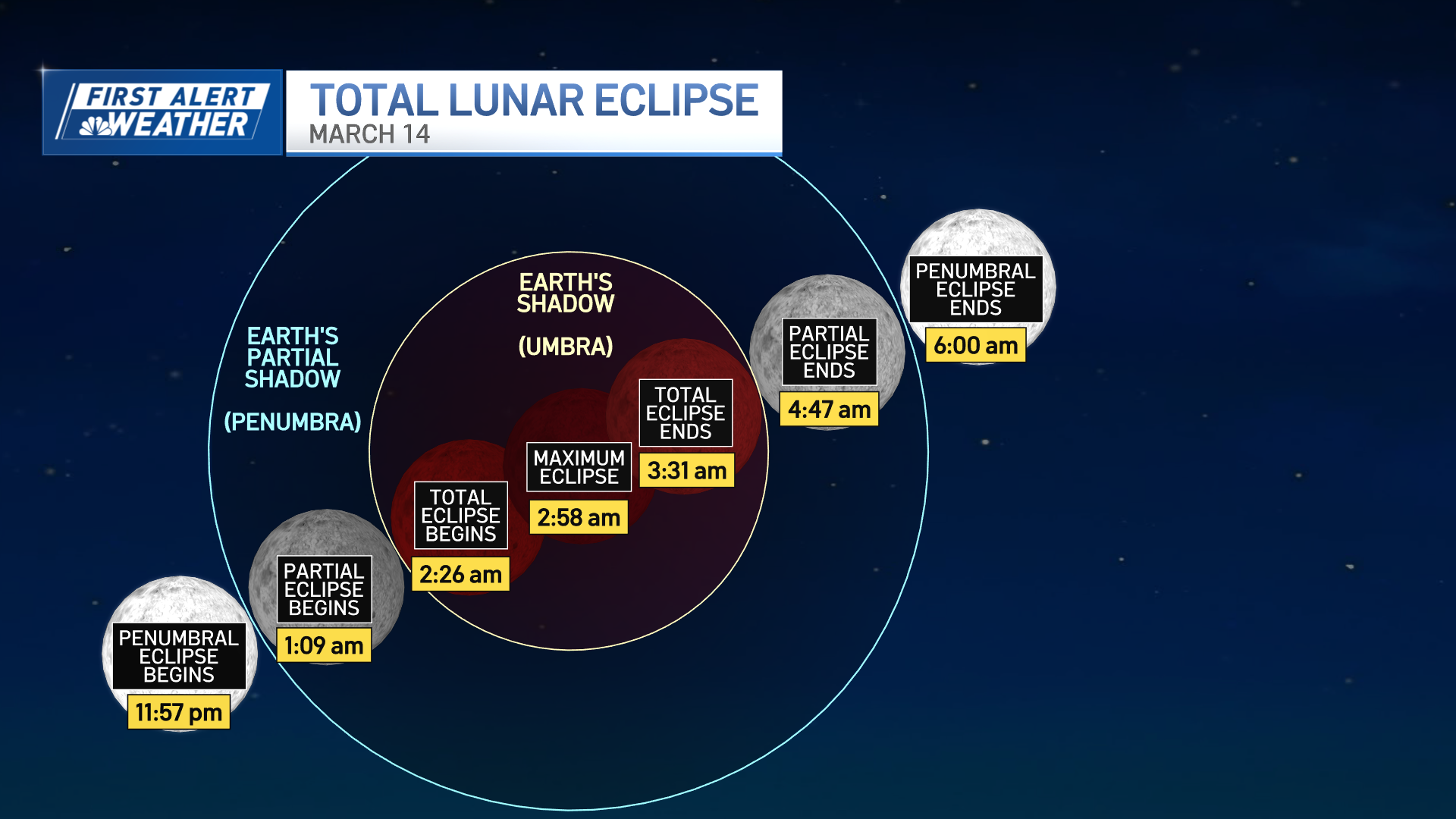
Friday morning, we have a total lunar eclipse with the maximum and the “blood” moon at 2:58 a.m.
How can I watch tonight's 'blood moon' lunar eclipse?
No protective eyewear is needed for this as the Earth passes between the sun and the full “Worm” moon, unlike a solar eclipse where you definitely need eye protection. In fact, on March 29, there will be a partial solar eclipse for the northeastern U.S.

Will the sky be clear for tonight's lunar eclipse in Boston?
But how well will we be able to see the eclipse here in New England, given the potential for cloudy skies? Here's a closer look, by region:

Use this interactive radar to explore cloud cover where you are.
Weather Stories


Temps return to the 50s and 60s Friday into the weekend. Friday will be near 50 as we transition to a warm front heading our way, with upper 40s at the coast and 50s inland.

Clouds increase Saturday as we jump to around 60 on a gusty south wind. The wind ramps up a bit for Sunday with highs in the mid to upper 60s!
Aside from the wind, the St. Patrick’s Day parades will be dry, partly cloudy and warm. Rain approaches Sunday night.

A large low pressure system will be trudging across the country this week. Each day, a series of severe weather will develop and cause major damage in spots.


The severe storm risk pivots to the East Coast for Sunday night into Monday morning.

Though the damaging wind, hail, and tornado threat remains to the south of New England, there will be some thunderstorms around Connecticut and Rhode Island to the south coast of Massachusetts Sunday night into Monday morning.
Then, temps fall during the day Monday into Tuesday but still reaching the 50s. More 50s and 60s are on the horizon next week.
