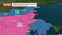
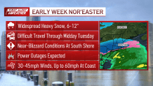
A mild Monday ahead of a potent nor'easter that will be bringing heavy snow, wind and coastal flood potential for Tuesday.

WATCH ANYTIME FOR FREE
Stream NBC10 Boston news for free, 24/7, wherever you are. |
By Tuesday's morning commute, whiteout conditions are likely. Very difficult morning travels that will bleed into the afternoon. This is across the region. Winds will gust above 30 miles per hour, with up to 55 mph gusts along the coast.
Boston winter storm impacts
Get updates on what's happening in Boston to your inbox. Sign up for our News Headlines newsletter.

By the afternoon, snow will begin to ease and winds begin to shift. Some snow will stay steady through the evening. Early afternoon will bring in the risk for at least minor coastal flooding from the New Hampshire coast to the Cape.
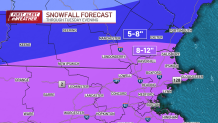
How much snow will Massachusetts and NH get?

Astronomical high tide will be paired with the push of water 1 to 3 feet on top of high tide. When all is said and done, 8 to 12 inches of snow is expected for most of the Commonwealth. Lower totals for areas south 3 to 5 inches likely along Cape Cod.
Track the storm with live radar
The rest of the week will be colder, with highs in the 30s and lows in the upper teens and 20s. Mainly dry for Wednesday and Thursday before our next system comes in on Friday.


