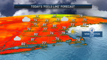
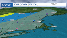
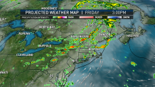
Thursday night: Lows in the upper 60s east, low 60s west. Few showers around. Friday: First Alert: Showers, downpours, thunder. Wind picks up, generally gusting 20-30 mph. Weekend: Drying out Saturday with few sprinkles, highs in the upper 70s. Sea breeze. Warm and dry Sunday, highs in the 80s.
Our incredible stretch of low humidity, comfortable air and fair weather will come to a close over the next 24 hours, but is set to return for the weekend.
A flash flood warning has been issued for Vermont's Addison County until 2 a.m. Severe thunderstorm warnings were also issued for parts of Vermont Thursday afternoon, but have since expired. For a list of severe weather alerts, click here.
WATCH ANYTIME FOR FREE
Stream NBC10 Boston news for free, 24/7, wherever you are. |
As the large dome of high pressure – fair weather – that’s been over the Northeast slowly drifts southeast off the Atlantic Seaboard Thursday, the clockwise flow of wind around its center will induce a southwest breeze for New England, gusting to 30 mph by late day over Cape Cod, generating some chop on our ocean waters of up to three feet by evening and producing a moderate rip current risk at ocean-facing beaches.

Get updates on what's happening in Boston to your inbox. Sign up for our News Headlines newsletter.
Although this southwest wind will carry more humid air into New England, the process will be slow and not all that noticeable at first. More noticeable Thursday will be some Canadian wildfire smoke drifting into our sky at high altitudes, not impacting air quality near the ground but adding a bit of a haze. Meanwhile, the atmosphere is already undergoing change — the jet stream winds aloft are hastening across southern Canada and the North Country of New England, and that fast wind high in the sky will steer a series of disturbances across New England through Friday evening, culminating with the passage of a surface cold front that opens up some great air for the weekend.
To get there, we’ll need to overturn the air and that will result in thunderstorms as soon as Thursday evening in the North Country, with northern Vermont susceptible to localized flash flooding and damaging wind gusts at that point, and scattered showers possible Thursday evening in the rest of northern and western New England. Although it’s possible an isolated shower breaks into southern New Hampshire or northern Massachusetts late Thursday evening, most of the action starts as showers and an embedded downpour predawn Friday, then gradually picks up in both areal coverage and intensity during the day Friday.

Through the morning to midday, showers, downpours and thunder will be scattered across the region, but will tend to converge most either side of a wide axis from Hartford to Providence to Boston, meaning more scattered action north and only a passing morning shower to a long lull over the Cape and Islands. By mid-afternoon onward, not only will some showers sag southeast toward the Cape, but new rounds of downpours and thunder will be possible for much of New England, raising the risk of localized flash flooding and isolated damaging wind gusts. With the passage of a late Friday evening cold front, less humid air will start its arrival to New England on a northwest wind and should deliver a great weekend, overall.

Saturday will feature some fair weather clouds that could produce an isolated sprinkle or light shower, but nothing to ruin a great day with comfortable air and highs near 80, then Sunday will be dry and in the 80s with the only impediment being increasing clouds over the day. Early next week, jet stream disturbances aloft raise the chance of a scattered shower Monday afternoon and a scattered thunderstorm Tuesday, but otherwise the week looks good with high temperatures generally 80-85 degrees, which actually will be a couple of degrees warmer than average for the second week of August.

