
While all the focus is on the weekend forecast, it's hard not to stomp all over the peace and quiet in the coming days. Wednesday is case in point. Still plenty of sun — along with a few clouds from time to time.
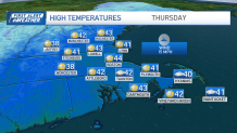
High temperatures get a little boost, as we aim for mid-40s in most spots. We'll hold near those values Thursday as more clouds pass through with a weak weather system.
STAY IN THE KNOW
Watch NBC10 Boston news for free, 24/7, wherever you are. |
|
Get Boston local news, weather forecasts, lifestyle and entertainment stories to your inbox. Sign up for NBC Boston’s newsletters. |
It's this weather system that taps into the cold and drops our numbers back to the 30s at the finish of the workweek. Both Friday and Saturday will stay dry, however.
Winter storm brings snow this weekend
Get top local stories in Boston delivered to you every morning. Sign up for NBC Boston's News Headlines newsletter.
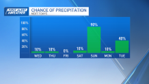
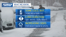
Saturday night the event gets underway, but the temperatures are only marginally cold with a steady east wind off 45-degree water. This could mean we start as rain — or wet snow that doesn't accumulate — through the first few hours of the storm.
How much snow is Massachusetts getting this weekend?
Weather

Later on Sunday (exact timing not well-defined yet), winds will turn to the north/northeast and the temperatures will fall. This will help turn the mix/rain over to accumulating snow that continues with varying intensities through the remainder of Sunday afternoon/evening.
It's noteworthy to mention that weather systems of this type are notorious for keeping the snow going long after the storm center has passed, so we'll watch for that Sunday night and any backend surprises, too.
All told, the numbers aren't blockbuster, nor are we looking at a snow bust. Six inches seems like a good focal point, with some lower near the coast and some higher in the Worcester Hills.
Admittedly, this storm has a low impact coming on the weekend and, without a lot of signs for heavy snow banding (like 1-3 inches per hour), it should be manageable.
Finer points and details to come as the shorter-range models come into view over the next day or two. Snow accumulation maps will continue to be refined up until the first flakes fly.
What we know about Sunday's snowstorm
This could be one of three storms to kick off next week. There's a large, milder storm slated for Tuesday and Wednesday. Lots of strong wind gusts are likely with this one. Then there's another possible storm at the tail end of next week — trending a bit colder.
Strap in for a wild kickoff to 2024.