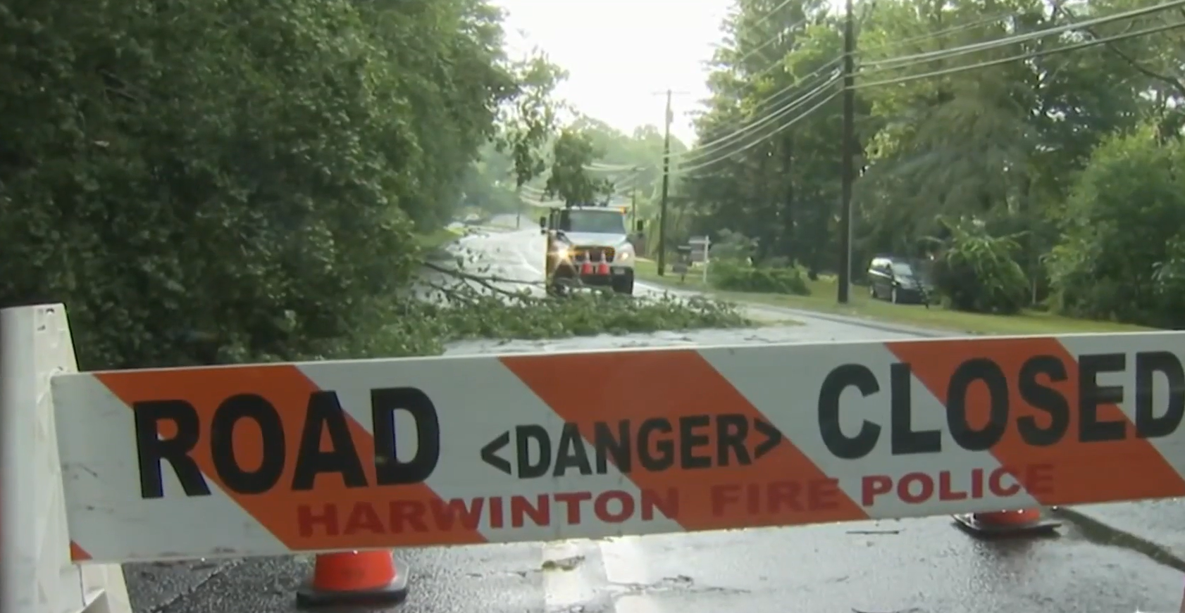
A flurry of tornado warnings rang out in New Hampshire, Connecticut and Vermont late Sunday afternoon and early evening, including around major cities.
The National Weather Service had yet to confirm whether any tornadoes actually touched down amid the intense weather in New England, where tornado warnings are rare.
STAY IN THE KNOW
Watch NBC10 Boston news for free, 24/7, wherever you are. |
|
Get Boston local news, weather forecasts, lifestyle and entertainment stories to your inbox. Sign up for NBC Boston’s newsletters. |
There were eyewitness and spotter reports of apparent funnel clouds in New Hampshire.
Get top local stories in Boston delivered to you every morning. Sign up for NBC Boston's News Headlines newsletter.

A Manchester couple tells NBC10 Boston they were at a restaurant having dinner when they got a dreaded phone call from a neighbor about their home Sunday evening.
Manchester's battalion chief says they were called to the Boynton Street house just after 6 p.m. for a fire after an apparent lightning strike. The fire was contained to the attic and a second-floor bedroom closet.
The Provenchers say there's a lot of water and smoke damage but they're just grateful no one was hurt.
In southern New Hampshire, there were tornado warnings for central Hillsborough County and parts of Rockingham and Merrimack counties until 6:15 p.m.
According to the National Weather Service, a severe thunderstorm capable of producing a tornado was located over Greenfield, or 12 miles northeast of Jaffrey, moving east at 40 mph. Radar indicated rotation. This storm included quarter size hail and screaming wind.
For the second alert, the NWS said a severe thunderstorm capable of producing a tornado was located over Goffstown, or near Manchester, moving east at 45 mph at 5:48 p.m.
A tornado warning was issued for part of Hartford County in Connecticut, expiring shortly before 6:30 p.m.
A severe thunderstorm capable of producing a tornado was located over West Hartford, moving east at 40 mph at 5:48 p.m., NWS said.
These tornado warnings were not the first for Connecticut and New Hampshire Sunday, either.
There was one issued earlier for southern NH Sunday, this one was issued for part of Cheshire County and expired at 5:15 p.m. This was an intense rain maker with half dollar size hail. It was one of three tornado warnings in New England active at the same time Sunday evening.
Another of the three tornado warnings was issued for part of Litchfield County in northern Connecticut. Ping pong ball size hail, intense lightning and localized flooding were possible with that storm.
The last of the three tornado warnings was in effect for parts of Lamoille, Chittenden and Washington counties in northwestern and central Vermont -- this was the second tornado warning for those counties today. The earlier warning expired around 3 p.m. and also covered part of Addison County.
A tornado watch remained in effect for a large part of New England, including at least one county in each state. It covers Boston, Worcester, Providence, Hartford, Manchester and Saco. It has since expired.
Severe thunderstorm warnings remain active in parts of Maine, Connecticut and New Hampshire.
Additionally, a flash floor warning is in effect for parts of central and northwestern Vermont through 7:45 p.m.
Get severe weather alerts for your area here, and track storms with live, interactive radar here:
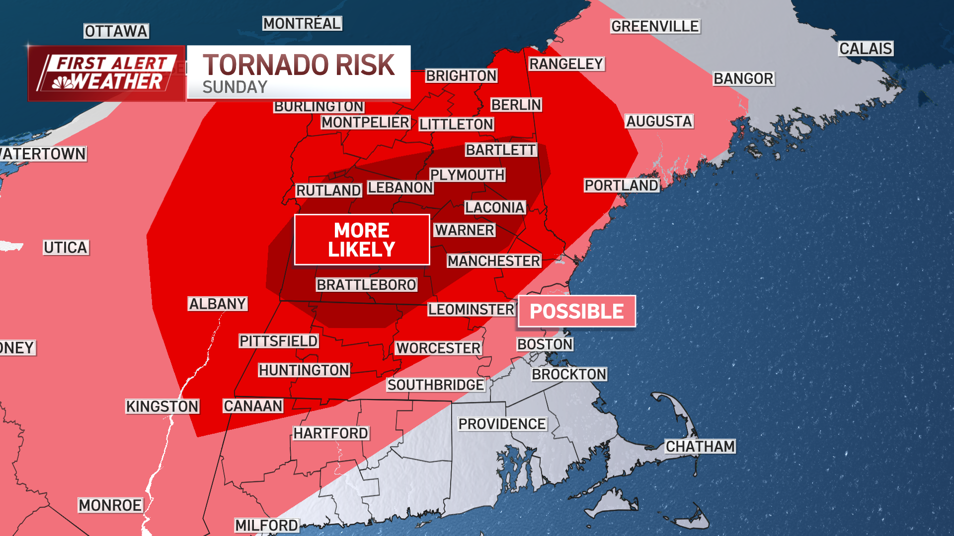
The weather will remain hot and humid, with heat indices in the mid to upper 90s. Hot temperatures combined with high humidity, will create conditions ripe for severe thunderstorms between 1 p.m. and 10 p.m.
The main concern is strong wind gusts that could cause damage. Additionally, heavy rain could lead to flash flooding, especially in urban areas. There is also a risk of tornadoes due to increased wind shear and favorable conditions for their development.

The highest tornado threat is for Vermont and New Hampshire. The severe weather threat will diminish by late evening Sunday, leaving only a few showers overnight.

Looking ahead to Monday through Saturday, the weather will become less humid with some showers possible on Monday. Tuesday will be dry and warm but with more tolerable humidity.
Another round of showers and thunderstorms is expected Wednesday into Thursday, with dry and less humid weather returning by the end of the week.