Winter weather continues this weekend. Watch the video to see what to expect.
Melting continues Friday with plenty of sun, and milder air... for now. But a cold front is blowing in with cooler air Friday night.
Winds will remain breezy Friday, with peak gusts near 45 mph across central Massachusetts and the Berkshires. Through Boston and the South Shore, gusts are likely near 30 mph.
WATCH ANYTIME FOR FREE
Stream NBC10 Boston news for free, 24/7, wherever you are. |
Friday night, as the cold air settles in, clear skies are around. Temperatures will start off in the teens and 20s Saturday morning, with sunny skies.
When will it start (and stop) snowing in Boston?
Get updates on what's happening in Boston to your inbox. Sign up for our News Headlines newsletter.
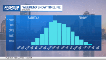
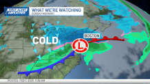
The afternoon gets cloudier with time as our next winter storm arrives. The storm will likely start just after sunset around 8 p.m. and ramp up earlier in the morning Sunday. Winter storm watches have already been issued for Saturday evening through Sunday afternoon for much of New England.
Intense bands of snow will set up through MetroWest and central Massachusetts, and along the Massachusetts Turnpike. The 1-5 a.m. timeframe is when the bulk of the snow occurs.
How much snow are we getting in Mass., NH?
Local
In-depth news coverage of the Greater Boston and New England area.


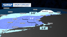
As it stands right now, most locations will pick up 5-8 inches of snow. While it’s not a guarantee, we are watching for the potential of higher totals through central Massachusetts. Temperatures will be marginal (near 30 degrees), but we do think most of this will be a heavier, pasty snow.
Unlike this past Thursday’s storm, timing will be in favor of snow lovers, as this will occur during the colder point of the day, away from the sun’s radiation.
For those with plans to watch the Big Game, roads should be much more improved by the evening before kickoff.