Our unsettled weather pattern has settled right in with scattered rain chances through Thursday.
Our humidity has increased again as well, while temperatures will remain in the 70s for most through Wednesday, thanks to an onshore flow.
WATCH ANYTIME FOR FREE
Stream NBC10 Boston news for free, 24/7, wherever you are. |
A stalled front just south of New England will bring us waves of showers and a couple thunderstorms for Tuesday into Wednesday.
Already on Tuesday morning, a flash flood warning was issued for parts of southern Maine, including the Portland area. See the latest weather alerts here.
Get updates on what's happening in Boston to your inbox. Sign up for our News Headlines newsletter.
While we see a few breaks of sunshine Tuesday, showers will redevelop anytime this afternoon and especially across the interior. And there could be a thunderstorm between 2 p.m. and 8 p.m., with some heavy rain and lightning.

Highs Tuesday stay in the 70s as we get a northeast flow, cooler coast. An area of low-pressure tracks across southern New England tonight into Wednesday, bringing more heavy rain to the south coast, Cape & Islands through Wednesday.
Northern Massachusetts isn't expected to see much rain, or any of northern New England, as the low is sharply cut off to the north. Highs again stay in the 70s.
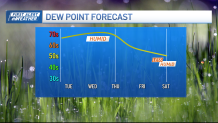
We have a cold front moving in on Thursday. Before that front arrives, our temps increase due to a southerly gusty wind. We're back in the 80s for highs along with higher dewpoints.
Scattered showers and storms move through Thursday, with an isolated chance for severe weather.

After that, we have an amazing stretch of dry weather upon us. The humidity is gone for a couple of days and doesn't increase until Monday next week. High temps reach the mid to upper 80s on Friday and Saturday with full sun.
Sunday through much of next week our highs will be around 90. Humidity returns by Monday, and rain chances increase Tuesday through the end of the 10-day.


