
Cold start again Wednesday, but there's more hope than Tuesday for sustaining the sunshine for at least some part of the day. While we won't promise complete blue, we will get some and get a bounce in the temperatures, too.
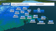
Highs should reach near 40 for many spots thanks to the southwest breezes. Thursday, we'll continue with the thaw as highs reach into the mid-40s areawide.
WATCH ANYTIME FOR FREE
>Stream NBC10 Boston news for free, 24/7, wherever you are. |
There aren't any major storms brewing across the east in the coming days. But with our flow coming from the northwest in the upper atmosphere, we'll see our mild stint get snuffed out by a cold front on Friday.
Get updates on what's happening in Boston to your inbox. Sign up for our >News Headlines newsletter.
This front may trigger a few widely scattered showers or high elevation snowflakes as it passes Friday afternoon, but its legacy will be a colder weekend with highs returning to the low 30s for both days.
Next week is also looking quiet, but the temperatures don't recover very quickly. Expect a slow crawl out of the 30s on Monday and Tuesday with a return to the low 40s late week.