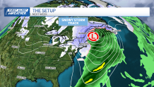
Here we go again, into another nasty rain/windstorm on the weekend. There are some similarities to Wednesday's event, but there are a couple of differences, too.
One of the major issues is the coastal flooding. We're in the new moon cycle, and this time around, the tides will be running higher than on Wednesday.
WATCH ANYTIME FOR FREE
>Stream NBC10 Boston news for free, 24/7, wherever you are. |

We're expecting the coastal flooding at the noontime high tide (1p.m. on the Vineyard/Nantucket) to be major at Hampton Beach, but otherwise minor to moderate on both Capes, Revere, Scituate, Provincetown and Martha's Vineyard.
Get updates on what's happening in Boston to your inbox. Sign up for our >News Headlines newsletter.
Southeast facing beaches are most vulnerable, thanks to the strong southeast winds through the night and into Saturday morning. Beach erosion, battering waves and high seas will be prominent through the morning and early afternoon Saturday.

We're not expecting a tremendous amount of rain this time around. 1 to 2 inches should cover it, without the snowmelt. This will be the reason flooding won't be as widespread, but since the rain will be coming down in such a short amount of time, we have the possibility of some minor urban flooding.
In addition, the added water will keep the rivers and streams near bankfull through the early week.
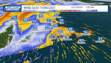
Gusts of wind won't be as fierce as Wednesday, either. Some speeds may peak at 50 to 55 miles per hour on the Cape, but the remainder of the coastline will generally see peak winds of 40 to 45 mph, with some isolated gusts near 50. Elsewhere, the winds will stay in the 40 to 45 mph range.

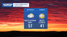
This storm is moving quickly, so the rain should exit by early morning, with the sun poking out by mid/late morning. The afternoon is dry and mild, but the cold swings in after dark. We'll see freezing temps Saturday night, and highs only near 40 on Sunday.
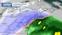
Next up is a colder storm on Tuesday night and Wednesday. Plenty of different paths that storm could take, so we’re not certain of a hit at this point.

Continuous updates through the weekend, online, on your favorite streaming service and on social media.
Be safe and enjoy your weekend!


